


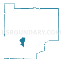
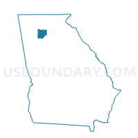
057024 - LIBERTY Voting District, Cherokee County, Georgia
About
Outline

Summary
| Unique Area Identifier | 560622 |
| Name | 057024 - LIBERTY Voting District |
| County | Cherokee County |
| State | Georgia |
| Area (square miles) | 4.96 |
| Land Area (square miles) | 4.93 |
| Water Area (square miles) | 0.03 |
| % of Land Area | 99.46 |
| % of Water Area | 0.54 |
| Latitude of the Internal Point | 34.17971670 |
| Longtitude of the Internal Point | -84.52118500 |
Maps

Graphs
Select a template below for downloading or customizing gragh for 057024 - LIBERTY Voting District, Cherokee County, Georgia


Neighbors
Neighoring Voting District (by Name) Neighboring Voting District on the Map
- 057009 - BRIDGEMILL Voting District, Cherokee County, GA
- 057022 - HOLLY SPRINGS Voting District, Cherokee County, GA
- 057034 - SIXES Voting District, Cherokee County, GA
- 057036 - TEASLEY Voting District, Cherokee County, GA
- 057037 - TOONIGH Voting District, Cherokee County, GA
Top 10 Neighboring County Subdivision (by Population) Neighboring County Subdivision on the Map
Top 10 Neighboring Place (by Population) Neighboring Place on the Map
Top 10 Neighboring Unified School District (by Population) Neighboring Unified School District on the Map
Top 10 Neighboring State Legislative District Lower Chamber (by Population) Neighboring State Legislative District Lower Chamber on the Map
Top 10 Neighboring State Legislative District Upper Chamber (by Population) Neighboring State Legislative District Upper Chamber on the Map
Top 10 Neighboring 111th Congressional District (by Population) Neighboring 111th Congressional District on the Map
Top 10 Neighboring Census Tract (by Population) Neighboring Census Tract on the Map
- Census Tract 907.01, Cherokee County, GA (19,523)
- Census Tract 903, Cherokee County, GA (11,555)
- Census Tract 907.02, Cherokee County, GA (7,180)
- Census Tract 906.01, Cherokee County, GA (6,841)